How to Analyze the Disappearance of a Lake: Lessons from Canada's Lake Rouge
Introduction
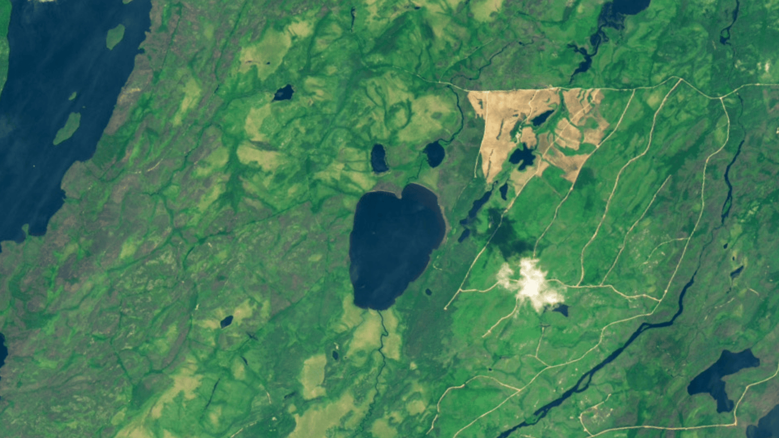
In a dramatic event captured by satellite imagery, Canada’s Lake Rouge—a body of water shaped like a startled emoji—completely vanished after one of its banks collapsed in a landslide-like failure. This astonishing transformation offers a unique case study for understanding how lakes can suddenly disappear. By following this step-by-step guide, you'll learn how to analyze such geological events, from initial observation to long-term implications. Whether you’re a geology enthusiast, a climate researcher, or simply curious about Earth’s dynamic processes, this guide will help you decode the forces behind a lake’s abrupt exit.
What You Need
- Satellite imagery from services like NASA Earth Observatory, Google Earth, or Sentinel Hub (before-and-after images essential)
- Geological maps of the region (showing soil types, bedrock, permafrost distribution)
- Hydrological data (water level records, precipitation, drainage patterns)
- Basic GIS skills (e.g., using QGIS to overlay layers)
- Access to scientific reports or news articles (like the original account of Lake Rouge)
- Notebook for recording observations and hypotheses
Step 1: Examine the Initial Conditions
Begin by studying the lake before its disappearance. For Lake Rouge, satellite photos from earlier dates showed a distinct, roughly circular basin fed by seasonal runoff and possibly groundwater. Note these key features:
- Shape and size – Lake Rouge had a unique “shocked emoji” silhouette, which was a clue to its fragile boundaries.
- Surrounding terrain – Steep banks, loose sediment, and proximity to a river or wetland can indicate instability.
- Vegetation and soil – Look for areas of exposed permafrost or signs of erosion along the shoreline.
- Water source – Determine if the lake was fed by a stream, glacial melt, or perched water table.
Use geological maps to identify if the region lies on thawing permafrost or loose glacial till—both can lead to sudden drainage.
Step 2: Monitor Over Time with Satellite Images
Satellite imagery is your most powerful tool. Compare images taken months or years apart. For Lake Rouge, pairs of images from before and after the collapse showed a dramatic change: one image displayed a full blue lake, the next a dry, muddy depression. When analyzing:
- Choose consistent seasons – Ice cover or snow can hide details; aim for summer images.
- Look for transitional signs – Was there a gradual decline in water level before the collapse? Or was it sudden?
- Measure changes – Use GIS tools to calculate the loss of surface area. Lake Rouge likely shrank rapidly within a short period.
Tip: Use the time-lapse feature in Google Earth to see the progression.
Step 3: Identify Trigger Factors
A lake doesn’t vanish without a catalyst. For Lake Rouge, experts cited a “multitude of factors” that combined to cause the bank collapse. Research the possible triggers:
- Landslide or bank failure – Heavy rains, seismic activity, or melting permafrost can loosen soil, causing a chunk of the bank to slide into the lake or away from it.
- Drainage through new outlet – A collapse can open a channel that rapidly empties the lake into a lower valley or river system.
- Climate-related thaw – In northern Canada, rising temperatures can melt ice-rich permafrost, turning solid ground into slush and destabilizing lake basins.
- Human intervention – While unlikely for Lake Rouge, check for mining, dam breaches, or road construction nearby.
Review local weather data for extreme rainfall events or unusual heat waves preceding the disappearance.
Step 4: Analyze the Collapse Mechanism
Now, synthesize your data to model how the lake drained. For Lake Rouge, the likely sequence is:
- Weakening of bank – Permafrost thaw or erosion reduced the structural integrity of the lake’s barrier.
- Initial breach – A small crack or slump occurred, perhaps during a rainstorm or thaw event.
- Cascade failure – The outflow widened rapidly, like a dam break, releasing stored water in a torrent.
- Complete drainage – The lake emptied within hours or days, leaving a dry basin.
Draw a diagram or use modeling software to illustrate how water would flow after the collapse. Confirm with satellite evidence of a new stream channel or debris fan downstream.

Step 5: Evaluate Long-term Implications
Lake disappearance has ecological and geological consequences. Consider these aspects:
- Ecosystem disruption – Aquatic life perishes, and terrestrial species may lose a water source.
- Sediment and nutrient release – The drained basin can become a source of dust or alter downstream water quality.
- Geological hazard risk – Nearby slopes may now be unsupported, increasing landslide potential.
- Climate feedback – Lost water bodies can affect local albedo and permafrost stability.
Researchers studying Lake Rouge will monitor the area for years to understand these effects. You can follow similar monitoring by revisiting satellite images or reading follow-up studies.
Step 6: Apply Lessons to Other Lakes
Finally, use your analysis to identify other at-risk water bodies. Features that make a lake vulnerable include:
- Presence of ice-rich permafrost in the banks
- High seasonal water level fluctuations
- Proximity to a steep downhill gradient
- Recent warming trends in the region
Create a checklist and compare it with satellite imagery of similar lakes in Canada, Alaska, or Siberia. Share your findings with online citizen science projects like the Global Lake Evaporation Database or Permafrost Watch.
Tips for a Deeper Understanding
- Use multiple data sources: Combine optical satellite images with radar data (e.g., Sentinel-1) to detect changes even through clouds.
- Ground-truth where possible: If you can visit a recently drained lake, take soil samples and measure the new topography.
- Consider climate trends: Long-term warming is a major driver of lake drainage in permafrost zones—check historical temperature records.
- Read scientific literature: Papers on “thermokarst lake drainage” provide detailed mechanisms that apply to cases like Lake Rouge.
- Stay updated: Satellite revisit times allow you to catch future collapses soon after they happen—set up alerts for specific coordinates.
By following these steps, you can turn a surprising news story into a practical investigation of Earth’s ever-changing landscape. Lake Rouge’s dramatic vanishing act is more than a curiosity—it’s a lesson in how interconnected forces can reshape our planet in a matter of days.